Other Name(s)
Battle of the Windmill
Battle of the Windmill National Historic Site of Canada
Bataille du Moulin-à-Vent
Windmill Point
Pointe du Moulin-à-Vent
Links and documents
Construction Date(s)
Listed on the Canadian Register:
2009/10/06
 Statement of Significance
Description of Historic Place
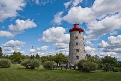
Battle of the Windmill National Historic Site of Canada is a fragment of a battlefield located on Windmill Point overlooking the St. Lawrence River at Newport, Ontario. The designated area for Battle of the Windmill battlefield comprises a semi-circular arc with a 400-metre radius that extends landwards from the windmill, and completed by another semi-circular arc with a 400-metre radius that encompasses the section of the river that borders the windmill. Only a small portion of this area is included in the property of the historic site. The designation is limited to the approximately 10 per cent of the battlefield, which is administered by Parks Canada.
Heritage Value
Battle of the Windmill was declared a National Historic Site of Canada site because:
- it was the site of a victory of a British force, comprised of imperial and colonial troops, over an invading force of American “Hunters” and Canadian rebels in November 1838.
The heritage value of Battle of the Windmill National Historic Site of Canada resides in the legibility of natural and built features of the cultural landscape associated with the Battle of the Windmill, and the undisturbed battle remains it contains.
Sources: Historic Sites and Monuments Board of Canada, Minutes, 1981; Commemorative Integrity Statement.
Character-Defining Elements
Key elements that contribute to the heritage character of the site include:
- the location on a high point of land overlooking the St. Lawrence River at Newport, Ontario;
- the remains of built features still associated with the battle including the windmill in its found form and materials, heavy masonry construction, and disposition of window and door openings;
- the viewplanes from the windmill to the surviving stone house;
- the integrity and legibility of surviving landforms and landscape features, both natural and manmade, that are linked to the battle, such as the trace of roadway, the heights of land to the north of the site, the remaining open fields, the shore line and the river;
- the integrity and materials of any surviving archaeological remains, features and artifacts in their original placement and extent, including in situ vestiges and marine archaeological resources associated with the battle;
- the visual and landscape character of the site including the panoramic viewscapes from the upper storeys of the windmill south across the river, up and down river, and north across the battlefield.
 Recognition
Jurisdiction
Federal
Recognition Authority
Government of Canada
Recognition Statute
Historic Sites and Monuments Act
Recognition Type
National Historic Site of Canada
Recognition Date
1920/01/30
 Historical Information
Significant Date(s)
1838/01/01 to 1838/01/01
Theme - Category and Type
- Governing Canada
- Military and Defence
Function - Category and Type
Current
Historic
- Defence
- Battle Site
Architect / Designer
n/a
Builder
n/a
 Additional Information
Location of Supporting Documentation
National Historic Sites Directorate, Documentation Centre, 5th Floor, Room 89, 25 Eddy Street, Gatineau, Quebec
Cross-Reference to Collection
Fed/Prov/Terr Identifier
496
Status
Published
Related Places

Windmill Tower
The Windmill Tower stands prominently on Windmill Point, a height of land near the town of Prescott, where it overlooks the old King’s Highway and the St. Lawrence River. The 62…

Windmill Point Lighthouse
The Windmill Point Lighthouse (also known as Battle of the Windmill Lighthouse and Windmill Tower) is an 18.9 metres (62 feet) round, tapered, stone tower crowned with a cast iron…